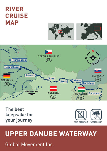
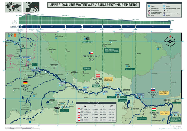
Upper Danube Waterways (Nuremberg - Budapest)
This map presents the Upper Danube waterways between Nuremberg Budapest and provides useful and interesting information.
The Danube River begins where two small streams (Breg and Brigach) come together on the eastern slope of the Black Forest Mountains in the town of Donaueschingen. It is from this point onward that it is actually known as the Danube, flowing generally southeasterly for a distance of some 2,850 km / 1,770 miles. Navigation for river ships on the Danube is only possible at Kelheim (then going on to join the Main Danube Canal to or from Nuremberg).
The Danube flows through ten countries (Germany, Austria, Slovakia, Hungary, Croatia, Serbia, Bulgaria, Romania, Moldova and the Ukraine.) This expansive river also passes through four capital cities. (Vienna, Bratislava, Budapest, and Belgrade), before emptying into the Black Sea via the Danube Delta located in Romania. It is the second longest river in Europe (after the Volga River in Russia) and has 31 main tributaries, and 60 varieties of fish.
Traditionally, rivers are measured by kilometers from the source to the end (the mouth), but the Danube is different and is measured starting at its mouth in Sulina, Romania (km 0), up to Kelheim (km 2411), ending at the source in Donauschingen (km 2860) with km markers on the banks of the river noting the progress.
Austrian composer Johann Strauss Jr, wrote his famous musical composition about the Danube, “Der schönen, blauen Donau” (On the Beautiful Blue Danube.) Unfortunately, the Danube has never been blue.
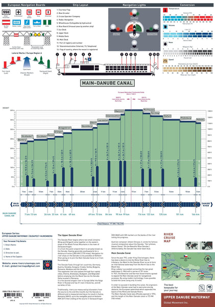
Main Danube Canal
Since the year 793, under King Charlemagne, there has been a desire to link the Rhine River (via its tributary, the Main) to the Danube River so as to form an international waterway from the North Sea to the Black Sea. King Ludwig I succeeded connecting the two great waterways in 1846 with a series of 101 locks. In 1921, the Bavarian and German Governments agreed to expand the Main-Danube canal for navigational purposes. By using modern technology, it was possible to build the canal using only 16 locks.
In order to succeed in building this canal, the engineers of the Main-Danube canal had to overcome one big obstacle, the European watershed which separates the basins of the Rhine and Danube Rivers. The Main-Danube Canal was officially opened in 1992, and the length of the Main Danube canal is 172 kilometers / 106 miles.
This valuable tool will enhance your river cruise experience and serve as a reminder of the wonderful journey that is found only on European rivers.
- Specially designed for river cruise passengers and travel agents
- Durable and user friendly
- Compact with accurate information
- Water proof and tear resistant
- Map Size: open: 16.5" x 23.4" (420 mm x 594 mm) folded: 4.1" x 5.8" (105 x 148 mm)
NOTE: To order in Europe, please email us : globalrivermaps@gmail.com
The content at rivercruisemaps.com is protected by copyright.
Unauthorized use of this material is prohibited.