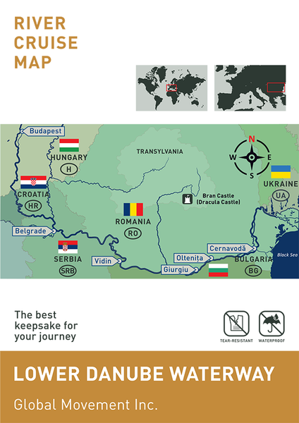
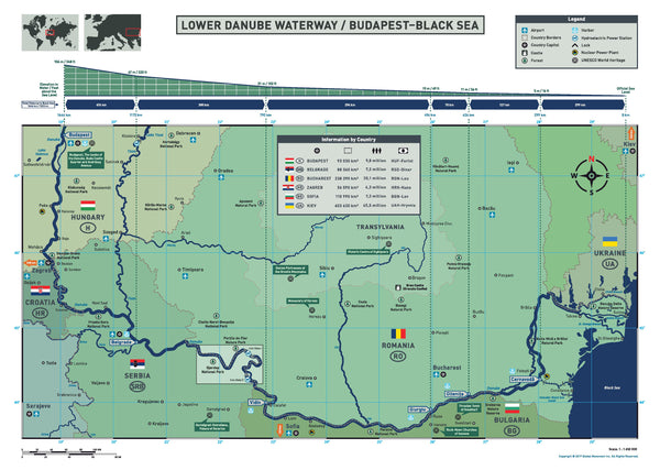
Lower Danube Waterway (Budapest-Black Sea)
The Danube from Budapest flows south, passes through the beautiful Pannonian Plain then becomes a mountain river and separates the Carpathian Mountains from the Balkan Mountains and after travel 1646 km (1023mi) emptying into the Black Sea via the Danube Delta. This part of the river was the site of the earliest human cultures and served as a significant cultural and historic boundary in Europe.
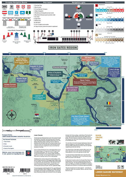
The Iron Gates (Porțile de Fier or Đerdapska Klisura ) is the largest gorge in Europe and one of Europe's most scenic landscapes. Here the river carves a passage through the limestone rocks creating rapids, whirlpools and struck fear into the hearts of sailors till 19th century are the series of four steep gorges. Divided by three ravines, it is the oldest geological valleys in this part of Europe and the biggest water breakthrough on the continent. The river banks on both sides of the border are under state protection as national parks. The Danube first enters the Golubac Gorge where is the magnificent Golubac Fortress than flows into the Liupkovska Valley. The second gorge is called Gospodin Vir (The Lady's Whirlpool) and the cliffs above it reach up to 500 m while the riverbanks narrows to 220 m apart. The broader Donji Milanovac forms the connection to the third gorge between Orsava valleys and is called Kazan (The Cauldron) with the Great (Veliki) and the Small (Mali) Kazan gorge. The fourth gorge, called Sip, begins at the exit of the Danube from the Orsava Valley and ends at the edge of the Wallachian Plain.
The Iron Gate I & II is the largest hydropower dam and reservoir system along the entire Danube. Jointly built in 1972 and 1985 by Romania and Serbia and operated respectively. The construction of these dams caused a 35 m rise in the water level of the river near the dam and additionally impound the river as far upstream as Novi Sad. The Danube island of Ada Kaleh and at least five other villages were relocated and the settlements have been lost forever to the Danube.
Where the Danube River flows into the Black Sea, forms the largest and best preserved of Europe's deltas. Danube Delta Biosphere Reserve Danube delta hosts over 300 species of birds as well as 45 freshwater fish species in its numerous lakes and marshes.
“Danube knocked and Iron Gate opened" -wrote Gerard de Nerval writer and translator Gérard Labrunie French Romantic poet.
This valuable tool will enhance your river cruise experience and serve as a reminder of the wonderful journey that is found only on European rivers.
- Specially designed for river cruise passengers and travel agents
- Durable and user friendly
- Compact with accurate information
- Water proof and tear resistant
- Map Size: open: 16.5" x 23.4" (420 mm x 594 mm) folded: 4.1" x 5.8" (105 x 148 mm)
NOTE: To order in Europe, please email us : globalrivermaps@gmail.com
The content at rivercruisemaps.com is protected by copyright.
Unauthorized use of this material is prohibited.